


company insight
FlySight, Geospatial Situational Awareness Solutions
FlySight is the Strategic Business Unit in Defence and Security of Flyby Srl, an Italian company specialized in the development of DSSs (Decision Support Systems) exploiting edge technologies in the fields of Remote Sensing and Big Data Analytics.
The FlySight Team provides solutions for design and development of state of the art C4ISR systems (Command, Control, Computer, Communication for Intelligence Surveillance and Reconnaissance).
The solutions proposed are based on AI (Artificial Intelligence) approaches exploiting the latest cognitive signal processing and adaptive data fusion algorithms. Typical applications are for avionics, naval and underwater sectors providing geospatial situational awareness both for the on-ground segment and for the on-board one.
Real time PED (Processing Exploitation and Dissemination) is allowed by the integration of our products in already existing architectures thanks to the interoperability of our systems with STANAG and OGC (Open Geospatial Consortium) standards.
Moreover, the adoption of Deep Learning methodologies coupled to Augmented Reality enables the definition of disruptive ISTAR (Intelligence Surveillance Target Acquisition and Reconnaissance) systems.
Flagship Product
The FlySight’s flagship product is OpenSIGHT, a Geospatial Solution for Processing, Exploitation and Dissemination.
This product is a modular cost-effective system resulting from over 10 years of experience in the development of on-board and on-ground solutions.
OpenSIGHT exploits real information in a synthetic environment for Geospatial Situational Awareness and provides a new approach in the definition of Decision Support Systems as a component of the TMC (Tactical Mission Command) or as a tool for the real-time mission analysis, enabling real-time collaboration in a COP (Common Operating Picture) of the scenarios.
The adoption of OpenSIGHT allows the integration of new solutions or it brings new fundamental capabilities in a Legacy Command and Control environment:
To process data from heterogeneous sensors in real-time (Electro-optical, Infrared, Hyperspectral, Radar, LIDAR, SONAR);
To layer information from multiple warfighting functions on 3D map displays or on Augmented Reality views;
To share information and commands, providing all parties with a real-time common view of the scenarios.
The built-in interoperability features (STANAG and MIL-STD) allow OpenSIGHT to directly interface NATO systems and to manage georeferenced data in already existing geodatabases (or to provide new solutions for geospatial information management).
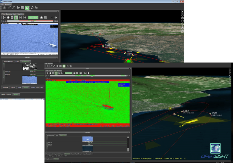
OpenSIGHT processing of a naval operation
Process heterogeneous data
Many processing functionalities are available to enhance the situational awareness and to support the decision process:
Real-time processing of EO and IR images/videos
The following functions are integrated into the real-time processing of EO (Electro-Optical) and IR (InfraRed) images/videos: Enhancing, Fog Suppression, Fusion, Electronic Stabilization, Tracking, Super Resolution, Mosaicking, Moving Target Indicator, Automatic Target Recognition, Simultaneous Localization and Mapping.
Real-time processing of hyperspectral images
The following functions are integrated into the real-time processing of hyperspectral images: Anomaly Detection, Features Segmentation, Features Classification, Features Recognition.
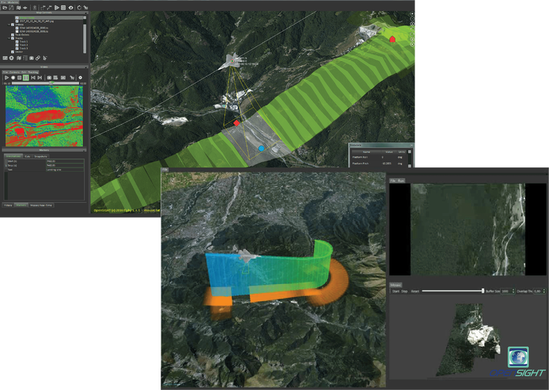
OpenSIGHT processing of an avionic mission
Manage common information layer
OpenSIGHT supplies and manages multi-layer information, either in synthetic 3D displays or adopting Augmented Reality solutions to enhance the human comprehension of operative scenarios.
The displays can be used to show a 3D rendered environment derived from merging a priori knowledge with the real-time information coming both from connected actors and from on-field sensors. The same pictures can be shown in Augmented Reality views, where all the information is overlaid on the scenario sampled by the adopted sensors.
SHARE INFORMATION:
OpenSIGHT exploits existing communication layers allowing the information sharing between the actors operating in the same mission. Tools for the dissemination of the information and commands are ready to be interfaced with legacy infrastructures.
Contact details:
Current FlySight solutions have been already adopted by many police departments in Europe.
FlySight team is ready to support you in building up the best solutions and to address your most challenging aims in command & control operative scenarios.
Flyby Srl