intelligence
Balancing access and security in geospatial intelligence
The growing availability of private-sector satellite imagery raises questions about who can access sensitive data. Alex Love hears from intelligence consultancy ShadowBreak how open-source technologies are bringing some transparency to the field and what it means for defence departments.
Access to satellite imagery is improving rapidly thanks to open-source platforms and private-sector involvement, moving away from being the reserve of mostly defence departments.
In January, 143 small satellites were launched onboard a SpaceX rocket, the majority intended for observational use. But as the number of satellites in orbit – and the amount of data they produce – increases, so does the need for organisation and control of who has access.
This is where companies like ShadowBreak come in. With its tagline of ‘democratising geospatial intelligence’, the intelligence consultancy offers solutions to collect and merge high-resolution satellite imagery with other databases for analysis.
Open-source satellite data
ShadowBreak works with clients from defence departments and commercial operations around the world, offering an extensive library of hi-res satellite imagery and the capacity to study a wide range of geospatial data. Its aim is to increase accessibility in these areas, providing aggregation and analysis capabilities through a centralised platform.
“What we are trying to do is making that data more accessible, to journalists and open-source investigators on a platform that actually allows them to access imagery from all providers, so they're not restrained or restricted in the way that they were before, in terms of minimum order values and other restrictions," explains Jasper Smallenbroek, ShadowBreak’s head of partnerships. “What we're seeing is that it's not just defence ministries and really large companies that have access to this type of data any more. It's really starting to trickle down.”
While defence departments may not be the most obvious area for open-source platforms that increase transparency, they are taking full advantage of the benefits this technology has to offer.
“I think the military have been embracing that shift in the industry, mainly because more data is always useful for the intelligence community,” says ShadowBreak co-founder and CEO Samuel Cardillo.
With the trend in satellite data usage going towards greater levels of openness, an important balance needs to be struck when it comes to confidentiality.
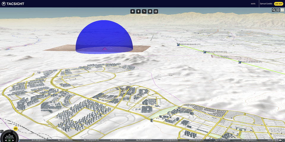
// ShadowBreak’s TacSight platform uses geospatial data to build a picture of what's happening on the ground. Credit: ShadowBreak International.
Protecting sensitive data
If an incident occurs, for example a plane is shot down anywhere around the world, ShadowBreak can likely provide hi-res images that pinpoint exactly where it took place, the altitude and speed, with a time stamp.
However, defence departments are understandably keen to avoid the location of their troops or assets being known in certain circumstances, with the potential to compromise both a mission and the safety of personnel. In addition, some countries may have restrictions on sharing images or data that may heighten diplomatic tensions. Yet due to the number of satellite data providers, it may still be possible to gain access to the required imagery and data.
“Sometimes it does create those situations where maybe troop movements are exposed, for example, which they would rather not have exposed,” explains Smallenbroek. “It puts the providers in a position where they maybe don't want to supply certain types of imagery. For example, we work with [companies] from South Korea, and they will not supply imagery over North Korea.
“Depending on the country, different providers will always have different sensibilities and restrictions. And that's again somewhere where having a lot of different suppliers is beneficial because we can usually get around that.”

Whoever plays a role in sharing that intelligence data needs to put in place some kind of regulation.
When gathering potentially sensitive information, it is important to have the necessary controls in place to stop it falling into the wrong hands. Measures are required to ensure that all parties are who they say they are.
Cardillo says ShadowBreak using strict screening procedures to identify bad actors, adding: “Whoever plays a role in sharing that intelligence data needs to put in place some kind of regulation, some kind of process. Our process is that we screen every new customer, we make sure that we have a full onboarding process to understand who is who, and who is going to do what. That's where those kind of processes are important, because it shows that it works when you spot those bad actors and stop them.”
He says the company has had contact from at least ten bad actors, with varying levels of sophistication. But due to the screening processes, all were unsuccessful in obtaining the desired data.
“They had a fake website,” Smallenbroek explains. “If you did just a very quick search for the website and didn't really look at it properly, you would think that it's real. But as soon as you actually click around on it, you realise that it's just some stock photos, and it's just a shopfront.”
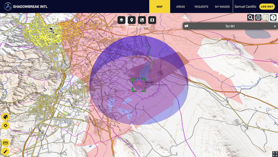
// The company’s military asset database enables the identification and real-time simulation of capabilities to determine threats posed. Credit: ShadowBreak International.
The rapid expansion of satellite coverage
The growing number of parties launching satellites substantially increases the depth and breadth of geospatial imagery and data available. In a very short space of time, this has dramatically changed the geospatial sector – a development that looks set to continue. Where there once was a scarcity of images, there is now an abundance. This increased competition will also bring down access costs.
“Two years or three years ago, the industry was totally different,” Smallenbroek explains. “And you were chasing the image in the past. An analyst was literally praying for an image to exist in the place he was looking. And today, the image is chasing you. There is suddenly a complete set of imagery from different kind of resolutions, different kind of times of the day, sometimes multiple times per day, in different places in the world.”
It is understood that this will soon lead to an excess of data, offering comprehensive coverage across land, sea, and skies. Data will be used by new market verticals other than solely defence. For example, agriculture is one industry that could benefit from a greater depth of imagery to monitor crops.
“We were getting to the point where there is going to be an overflow of data of that intelligence, that's where ShadowBreak comes in,” adds Cardillo. “That's where we bring some kind of centralised, easy way for all that data to finally be easily acquirable.”
Own a satellite
Open-source technologies are not expected to fully dominate the geospatial domain; there will always be a place for private satellites. In fact, the ShadowBreak has recently signed a collaboration agreement with Axelspace for solutions that fill this requirement.
Under the partnership, Shadowbreak’s data infrastructure will be used with Axelspace’s ground stations and microsatellites. Customers will gain secure access to imagery and intelligence through what is essentially their own personalised constellation.
“The idea is that our customers could come to ShadowBreak and then together with Axelspace, can design their own GEOINT capability,” says Smallenbroek. “Owning your own satellite would mean that it's highly secure, and nobody would really know what you're looking at, and when you're looking at it. So that would be a massive advantage to a defence department, for example, to actually be able to monitor in a silent way without that data becoming publicly available.”
With more satellites being launched into orbit, it does raise the question of whether there is an increased risk of collisions. However, Smallenbroek does not expect this to be a major issue provided there is careful planning and monitoring. “Space is vast, so there's still a lot of room for us to launch more satellites around Earth's orbit. But we have to be mindful,” he says.
// Main image: ShadowBreak’s TacSight platform uses geospatial data to build a picture of what's happening on the ground. Credit: ShadowBreak International.